Turnpikes
Monuments
In the Industrial Age
Fingerposts
From Earliest Times
Travellers in ancient times would have to ask the local people the way
but in more remote mountainous and moorland areas of England many winter travellers died when they lost their way in poor
weather conditions. Wayside markers were erected, at first simple cairns or heaps of loose stones, then standing stones
used by the Romans.

This Roman marker stands alone in a field in Middleton,
Cumbria to the west of the A683. The stone is a cylindrical sandstone shaft about 0.5 metre wide and about
1.7 metres above ground. At times the modern road along the valley follows the course of this Roman road.
The stone’s inscription was originally ‘M P LIII’ standing for ‘MILLE PASSUS 53’ or fifty-three thousand
paces (a pace being two steps forward, left then right) or 53 Roman miles, about the distance to Carlisle.
It was unearthed in 1836 by Richard Bownass, the farmer at Hawkin Hall, when the field was ploughed. The
words ‘SOLO ERVTVM RESTITVIT CVL. MOO[R]E AN~ MDCCCXXXVI’ were added on the instruction of Giles Moore of
Grimeshill, meaning “restored from the soil by Giles Moore 1836”. The stone is now a Listed Monument.
Wayside crosses were erected from the time when Christianity first reached England and the tradition of erecting crosses
at junctions continued until at least the 15th century. They were put up for religious or charitable reasons
or as memorials to individuals. However many were damaged during the Reformation and Commonwealth periods and
only survive unchanged in remote areas.

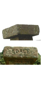
This Yorkshire guide post is known locally as the Hope Cross -
the inscription ‘HOPE’ appears on the front of the top stone, EDALE on the left and SHEFFIELD on the right.
It stands the route of the old Roman road between Win Hill and Lose Hill and which originally linked Hope
to Glossop. It is west of the A57 Snake Road across the Ashop stream feeding Ladybower reservoir.
It was a simple development to carve the name and distance to a nearby town with an arrow or pointing hand to show the direction.
On the Pennine Hills these are called Guide Stoops.
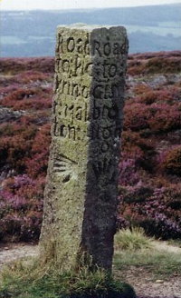
This Guide Stone is on the North York Moors but its exact
location is unrecorded. It indicates the way to Guisborough, Pickering and Malton.


On Rudland Rigg, south of the Cleveland Way and east of Cockayne,
this stone waymarker records ‘KIRBY RODE’ meaning Kirbymoorside on one side and ‘STOXLE RODE’ meaning Stokesley
on the other. It may have been put up in reponse to an order made around October 1711 to erect guidestones
throughout the North Riding of Yorkshire and is placed beside the old Waingate track.

Another stone on Urra Moor beside the Cleveland Way
near Round Hill. This Hand Stone has hands pointing east ‘THIS WAY TO KIR’ meaning Kirbymoorside and west
‘THIS IS THE WAY TO STOXLA’ meaning Stokesley. This is on a second ancient trackway between these
towns called the Thurkilsti track.
An Act of Parliament in the 1630’s in Elizabeth’s reign forced everyone who
occupied land within five miles of Oxford to contribute to the repair of the roads within one mile of Oxford, and supervisors had
to be nominated by the Mayor and Vice-Chancellor to execute these repairs. This was an ingenious solution to getting remote parishes
to contribute to the repair of the road which they used to reach the local market. These sections of road were called mileways and ran
in four direction out of Oxford - north from St Giles’ Church, south from Folly Bridge, east from Magdalen Bridge, and west from Osney
Bridge. The limit of each way was marked by a Mileway stone.
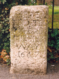
This boundary stone is on the Old Road near Cheney Lane in Headington, Oxford. When
this stone was erected the present London Road didn’t exist and Cheney Lane marked the start of the main route eastwards to London via
Old Road and Shotover. It reads ‘HERE ENDETH OXFORD MILE HY WAY 1667’.

This impressive Guide Stone is on the A422, Banbury to Stratford road, North Newington
Road, on NW edge of Wroxton Village, at a minor road junction. It is on the south side of road. It has sundials on each of the upper faces.
The pointing hands show the directions of London, Stratford, Chipping Norton and Banbury. The plaque records it was ‘FIRST GIVEN BY MR.
FRAN. WHITE IN THE YEAR 1686’. It is now a Grade II Listed Monument.
The practice of erecting waymarkers was formalised in 1697. William III passed
an Act decreeing that in the more remote parts of the kingdom, where two or more paths intersected, local Surveyors were to erect
guide stones showing the way to the nearest market town. These stones predated the advent of the turnpike roads, and because the project
was not properly funded, there was considerable variation in the enforcement of this ruling across the country. The parish of Bradfield,
near Sheffield, has stones which appear to be erected in response to the Act although this one is dated a lot later, 1753. It is on an
unclassified road near White Lee Moor plantation on the north side of road. It was erected by Bradfield Parish and on the four sides it
reads ‘PENISTON - R 5 M : LC - PD - Ip17 : Bradfield - R 1 M - 1753 : Sheffield - R 6 M’. The meaning of RM is a mystery;
Road Miles seems too ordinary.


Later in the 17th century the advent of the Royal Mail with staging points focused
attention on the main roads again. The post riders had to make good time and milestones were used to measure progress. One
of the earliest roads with milestones from this time is the Cambridge to Barkway road which was the start of the coach road to London.
The Trinity Hall series of milestones runs 16 miles between Cambridge and
the High Street, Barkway, a village south-east of Royston in Hertfordshire on B1638, London Road. Robert Hare was the
executor of the estate of Dr William Mowse who died in 1586, leaving about £1000 for charitable use. Hare added £600
himself and purchased the manor of Wallpool. The rent was to be used for the maintenance of the roads around Cambridge.
Dr William Warren was a trustee of this charitable fund and a Fellow of Trinity Hall, who began to survey the coach road
to London in 1725. He selected the south-west buttress of church of Great St Mary’s church, Cambridge as his survey datum,
and using a surveyor’s chain (which measured 66ft) he measured the distances and had this series of milestones installed.
Most of the milestones on this route are decorated with the crescent arms of Trinity Hall. This was all done before
the road became a turnpike.
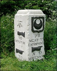
This stone is on the north verge at the junction of B1368 and A505. You can
see the date as AD MDCCXXXI (1731). Hands point to Royston, to Whittlesford and gives the distance XI (11) miles to Cambridge.
It also has the Trinity Hall arms and a later addition, the Ordnance Survey datum level arrow and line.
In June 1940, the government decreed that all placenames should be hidden or
removed, so as not to inform the enemy in case of invasion. According to Charles Crawley’s history of Trinity Hall, the
roadman laid the stones down and hid them in the verge. They were re-erected in 1946.
Turnpikes
The first Toll Road was set up on the Great North Road out of London in 1663 as a
way of collecting funds to maintain the road. From 1706 a series of Turnpike Trusts were set up which had the voluntary duty
of setting up toll gates, toll houses and mile markers with distances shown. Turnpikes were not liked but ‘Turnpike Mania’
took hold between 1751 and 1771 and over 300 Acts were passed by Parliament for individual sections of road. The routine
installation of milestones or mile posts on turnpikes was carried out from 1740 onwards but in 1766 the General Turnpike Act made it
a statutory requirement.

This large stone is located on the western verge of the B660 between Catworth and
Kimbolton in Cambridgeshire and is simply lettered ‘KIMBOLTON 3 MILES’.

On the north side if the A390 west of Newbridge, this interesting marker stone was
placed by the Callington Turnpike Trust between Newbridge and St Ive. It simply says ‘TAKE OFF’. The Trust allowed the use of an
extra horse to help get up the steep hill from Newbridge, over the river Lynher to St Ive. The marker informed wagon and coach drivers
that they must unhitch the extra horse at this point. The horse would then return down the hill to the tollhouse keeper at Newbridge.
The old turnpike road is now a quiet by-road and the main A390 now uses an easier route to the north.

This milestone is on the south side of the B3247 in Cornwall. North-west of
Millbrook and just east of a crossroads with Withnoe Lane. It shows that it is ‘4 mile from Mo’ Edgecumbe’.

A slate milestone on the bridge over the River Crafnant in Trefriw on B5106. The River
Crafnant leads into the River Conwy in the village. The milestone is a horizontal design and is on the old stone bridge in the
centre of the village.

An unusual stone is found on the old Coach Road near Barnhill Farm,
just north of Broxton in Cheshire and east of the A41. It marks ‘the halfway house from Chester to Whitchurch 10 miles each’ and is
dated 1761.
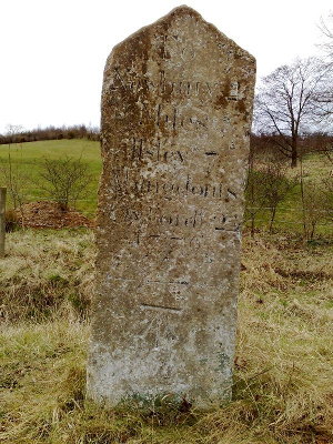
An impressive dated milestone is opposite the Fox & Hounds pub on the
Oxford Road which is a quiet unclassified road north of Donnington. Either side of this site are the A34 and A339 main roads.
This little road was once the main route from Newbury to Oxford. The stone is dated 1776 and is inscribed: ‘To Newbury 2 miles
Ilsley 7 Abingdon 18 Oxford 24 1776’ and what is possibly an Ordnance Survey benchmark level arrow has been added below.


Two milestones from far apart. On the left, this enigmatic Yorkshire stone
is on the A67 on the south verge at Arlaw Banks between Barnard Castle and Darlington whose initials and the number of miles alone
appear. On the right this neat milestone was in a country area on the B4214 at Staplow, north of Ledbury, Herefordshire just to the
north of The Oak PH. It is no longer to be found since 2016.
Monuments
The milestone reached its high point, literally, with the appearance of the
obelisk milepost. Most, including these shown, are Listed Monuments; these are Grade II.

The obelisk on the High Street at Nayland, near Ipswich in Suffolk is inscribed on the
front, 55 miles from London, 26 miles from Chelmsford, 22 miles to Bury [St Edmunds]; on the left side, 8 miles to Hadleigh and on the
right side, 6 miles to Colchester. The later stone horse drinking trough commemorates the crowning of King George V in 1911. From a
photograph by John V. Nicholls, Jan 2006.


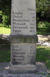
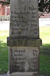
With distances to 36 towns and cities shown, this fine example is at Craven Arms in
Shropshire on the A49 road at its junction with the Clun Road, B4368. It is late 18th century, made of sandstone, and formerly
lime-washed.
In the Industrial Age
The next significant change in waymarking was the use of cast iron
plates which were either mounted on new stones or attached to existing ones.

This milestone on the north verge of the A5 at Coed Maesnewyddion,
west of Betws-Y-Coed, Wales. It is one of a series erected by the civil engineer,Thomas Telford, along the A5 road when he carried
out road improvements between 1817 and 1832. It shows ‘HOLYHEAD 43 C.CURIG 3M — 5F CERNIOGE 10M — 6F’. The distances
are in miles and furlongs and C.Curig stands for the town of Capel Curig.


This cast iron triangular milepost is on the old Great North Road at Water
Newton, Cambridgeshire (now called the A1 Trunk Road and moved to the village by-pass road). It was cast by ‘BARWELL & Co
FOUNDRY NORTHAMPTON’ and records ‘LONDON 81 STILTON 6 and STAMFORD 8’.
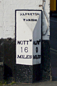
The zero mile point is usually a tourist feature of major cities. Probably earlier
is this milepost in the centre of the town of Alfreton in Derbyshire on the corner of Chesterfield Road and Church Street. It records
‘ALFRETON PARISH NOTTM 16 MILES ALFRN 0 MILES’ (short for Nottingham and Alfreton).

This lovely Uckfield Bells milestone is a metal mile post on the old main road through Uckfield, Eastbourne Road. It shows a distance of 45 miles possibly from St Mary Le Bow Church in the City of London if the bells on the post are Bow Bells made famous as the bells that made Dick Whittington return to London and become Lord Mayor. However the church is north of the Thames and the milestones are south and the bells do look more like flowers. Eastbourne Road runs north from A22 nearly opposite the entrance to East Sussex Golf Club and, before it forks, the post is on the right.

This straightforward triangular cast iron milepost is
situated on the south verge of the main Hereford to Worcester road, A1403, at Storridge just east of the church.


On the A65 SE of Kendal at the junction with the minor road to Stainton. This
cast iron milepost dated 1826 stands on the north side of the road near the new bus shelter. The A65 runs from Yorkshire into the
Lake District, ending at Kendal. This road crosses the A6070 which runs south to Burton and Lancaster. In times past the
Burton road was the more important route and the A65 leaving Kendal is called ‘Burton Road’ and the milestones give the distance to
Burton and not Kirkby Lonsdale or Skipton. It was manufactured by a company at Gatebeck.
The last turnpike trust ended 1885 and in 1889 the newly formed County Councils
took over responsibility for main roads and in 1894 the Rural District Councils took responsibilty for local roads.

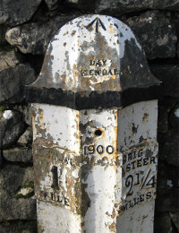
This is a more modern cast iron wayside marker dated 1900 on the
Brigsteer Road in Kendal, Cumbria. It is by a stile at the start of a path across the old race course. It is the same
pattern as the previous one but made by a different manufacturer. It says ‘DAY KENDAL’ on the top face and the Ordnance
Survey has taken a level from the top as shown by the added arrow.

As traffic speeds increased in the 1930s, ‘Bradley’ stones were designed and installed
by Worcestershire County Council’s deputy road surveyor, Mr Harold Brook Bradley. These unusually shaped concrete milestones
replaced the missing milestones on the A44. The CCW at the bottom stands for Worcestershire County Council, initials written
backwards so as to distinguish it from the nearby Warwickshire County Council. This marker is on the south verge of the A44 just
east of its junction with the A4440.
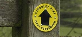
Today the term ‘waymark’ is used for marked walking trails such as this
example on a walk near Hebden Bridge in Yorkshire.
Fingerposts
Signposts first appeared in 1697 when legislation allowed magistrates to
have direction posts erected at highway junctions. The oldest recorded may be the wooden post that used to stand near Chipping
Campden in Gloucestershire and was dated 1669. This fine example is at Jockey Hill on the north side of Crediton in Devon.

In 1766 a General Turnpike Act made fingerposts compulsory on turnpikes. These
are the three famous Dorset Red finger posts. Spread around the county, they seem to be a combination of wooden fingers
and cast iron posts.
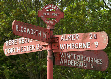


The story is that the first, just east of Bere Regis and recently restored, may have marked the route of prisoners being led from
Dorchester gaol to Portsmouth for deportation. The other two are farther north, one on the B3145 north of Sherborne and one is
halfway between Yeovil and Dorchester just west of Evershot on the happily named, Horsey Knap.
Wooden fingerposts have all gone or been replaced but cast iron fingerposts
have not all disappeared. Straying north of the Border, here is an original from Ayrshire erected in the 1920s. Road numbers had been allocated to A roads
- Main roads, B roads - Minor roads and C roads - Local roads. The process started in 1919 and was only completed by 1926.
This is on the B4075 south of Ayr and the base records it was made by the Royal Label Company in Stratford-on-Avon. This Company
is now (2010) based in Buxton, Derbyshire and is part of Leander Architectural.


Replacements for the old cast iron guideposts have fingers made from mild steel with individual letters and hands spot-welding
in place and the whole galvanised and painted.
Into the motoring age
In 1958 motorways were being constructed and signs became linked to road junctions. The Anderson Committee chaired by Sir Colin Anderson came up with white on blue signs using new typefaces especially developed for motorway signing by Jock Kinneir. The principal new font was a modification of the established sans-serif font called Aksidenz Grotesk.


Odinary road signs were improved by the Worboys Committee report in 1964 under the
chairmanship of Sir Walter Worboys. Their recommendations together with the Vienna protocol led to a standard European road
signage. The ‘Transport’ font was developed by graphic designers Jock Kinneir and Margaret Calvert.


As a last word in the development of waymarks from simple carved stones to the
modern sophisticated information technology, this is the latest solar-powered L.E.D. sign on the unfenced roads of the North York Moors
National Park. Not strictly a waymark but a simple warning message that on the way ahead you neeed to be beware of wandering sheep!

Sources:
http://www.waymarking.com under Category Signs/MilestonesThe Milestone Society http://www.milestone-society.co.uk
Worcestershire Group of the Milestone Society Finding Worcestershire Milestones 2007 ISBN 978-0-9557538-0-0
http:/www.geograph.org.uk
Raymond H Hayes Old Roads & Pannierways in North East Yorkshire publisher: North York Moors National Park Information Service
Ayrshire History by David McClure, Fingerposts http://www.ayrshirehistory.org.uk/Fingerposts/fingerposts.htm
Ayrshire History by David McClure, Milestones http://www.ayrshirehistory.org.uk/milestones/index.htm#montgreenan
Pictures courtesy of:
Alan Rosevear — Wroxton, BradfieldChris Marshall — Anderson sign
Duncan Harris — Alfreton
Martin and Jean Norgate — Middleton
kirk — Urra
Frank M. Firth — Rudland
David McClure — Ayr
Stephanie Jenkins — Headington
Michael Newbury — North York Moors